Trail Walking La Croix-Helléan - Circuit de Saint Maudé - La Croix Helléan - Photo

Circuit de Saint Maudé - La Croix Helléan

 tracegps
tracegps

User

© OpenStreetMap contributors
Length
Length
9.4 km
Max alt
Max alt
78 m
Uphill gradient
Uphill gradient
125 m
Km-Effort
Km-Effort  
11.1 km
Min alt
Min alt
28 m
Downhill gradient
Downhill gradient
127 m
Boucle
Boucle
Yes
Creation date :
2014-12-10 00:00:00.0
Updated on :
2014-12-10 00:00:00.0

(0 Reviews)

Walking
Walking
2h15
Difficulty : Medium

Scan this QR Code to open this trail in the SityTrail application

FREE GPS app for hiking

Logo SityTrail SityTrail

IGN / Geographical institutes

Download SityTrail from the App Store Download SityTrail from Google Play

Logo SityTrail SityTrail World

The world is yours!

Download SityTrail from the App Store Download SityTrail from Google Play Download SityTrail on Huawei AppGallery

About

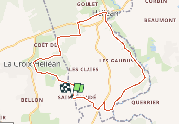
Trail Walking of 9.4 km to be discovered at Brittany, Morbihan, La Croix-Helléan. This trail is proposed by tracegps.

Description

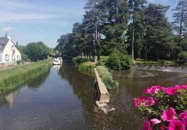
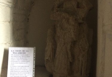
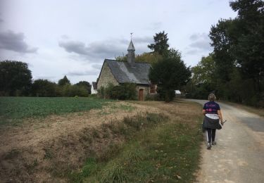
Point de départ : Chapelle Saint Maudé (commune de La Croix Helléan) - Coordonnées GPS : 02°29’11’’O / 47°57’03’’N - Distance : 9 km - 2 h 15 A voir en chemin : 1. La chapelle Saint Maudé : elle fut édifiée en 1431 à l’emplacement où furent enterrés les chevaliers tués au Combat des Tente. Œuvre unique en France, les vitraux contemporains ont été réalisés par Olivier Debré. Ces vitraux ainsi que les sculptures de style flamboyant lui donnent un charme tout particulier. 2. Le Ninian : autrefois, les moulins à eau faisaient le charme de ses rives. Aujourd’hui, cette rivière est réputée pour ses truites … pour la plus grande joie des amoureux de la pêche. 3. Hélléan : dans le bourg vous découvrirez l’église paroissiale du XVème siècle dédiée à Saint Samson, avec son clocher carré, ses vitraux modernes et un remarquable cadran solaire. Elle abrite un retable en bois du XVIIIème siècle, et un tableau de 1635 « la donation du Rosaire » Contact Office de tourisme de Josselin . Email : ot.josselin (at)wanadoo.fr

Elevation profile

Positioning

Country:
France
Region :
Brittany
Department/Province :
Morbihan
Municipality :
La Croix-Helléan
Location:
Unknown
Start:(UTM)
538357 ; 5310932 (30T) N.

Trails nearby

Trail Walking Taupont - GR_37_CG_41_Taupont_Josselin_20221015 - Photo
Walking
patrickdanilo

Walking

Very difficult
Taupont, Brittany, Morbihan, France
21 km | 25 km-effort
5h 18min
No
Trail Walking Josselin - GR_37_DA_01_Josselin_Pleugriffet_20200307 - Photo
Walking
patrickdanilo

Walking

Very easy
Josselin, Brittany, Morbihan, France
16.8 km | 18.9 km-effort
3h 55min
No
Trail Bicycle tourism Josselin - De Josselin à Pontivy - Photo
Bicycle tourism
ilur56

Bicycle tourism

Medium
Josselin, Brittany, Morbihan, France
52 km | 58 km-effort
4h 42min
No
Trail Hybrid bike Josselin - Josselin Redon jour 4 - Photo
Hybrid bike
Roulland

Hybrid bike

Easy
Josselin, Brittany, Morbihan, France
63 km | 70 km-effort
3h 31min
No
Trail Walking Josselin - Boucle de Josselin - Photo
Walking
yago1404

Walking

Easy
Josselin, Brittany, Morbihan, France
7 km | 8.3 km-effort
1h 41min
Yes
Trail Other activity Taupont - taupins - Photo
Other activity
bourdet

Other activity

Very easy
Taupont, Brittany, Morbihan, France
21 km | 24 km-effort
5h 59min
No
Trail Mountain bike Josselin - Josselin velo - Photo
Mountain bike
pln

Mountain bike

Easy
Josselin, Brittany, Morbihan, France
21 km | 24 km-effort
2h 8min
No
Trail Walking Guillac - Guillac  - Photo
Walking
motardfou.dgs

Walking

Very easy
Guillac, Brittany, Morbihan, France
8.8 km | 10.3 km-effort
2h 0min
Yes
Trail Nordic walking Taupont - 2018-09-30 TAUPONT CHEMIN DES CHAPELLES - Photo
Nordic walking
rousseau.mich

Nordic walking

Very easy
Taupont, Brittany, Morbihan, France
11.5 km | 13 km-effort
2h 36min
Yes


Close
My subscriptions